Fire data
Most Wildfires Stay Small. A Few Burn Almost Everything.
In 2026's US fire records, more than three-quarters of fires stayed under 10 acres, while 131 large fires burned nearly three-quarters of the land.
Open a wildfire map in summer and it can look like the whole West is burning. Most of those dots, though, are fires that firefighters caught within hours. We grouped every US fire record in FireRadar's database discovered between January 1 and October 31, 2026 by its final reported size, and the result is one of the most lopsided distributions in natural hazards.
The numbers
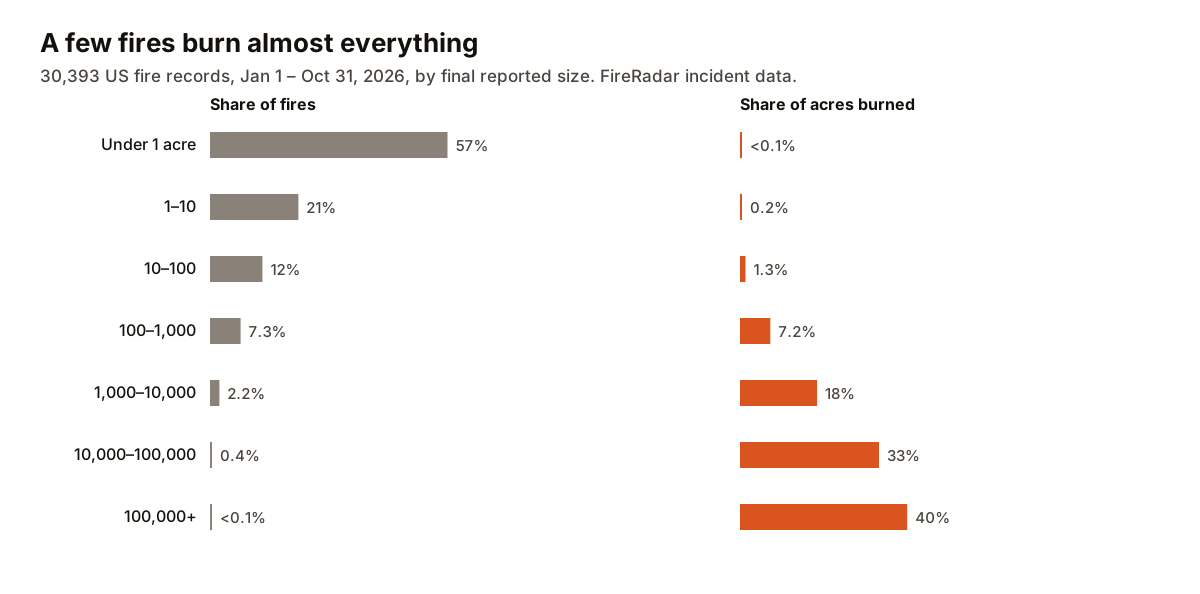
- 57% of fires — 17,183 of them — were under 1 acre — smaller than a football field.
- 78% stayed under 10 acres. Together, those 23,578 fires burned around 22,000 acres: about 0.2% of the roughly 10.2 million acres burned.
- Just 131 fires grew past 10,000 acres. That's under half a percent of all fires, but they burned about 7.4 million acres — 73% of everything.
- The 17 largest, each over 100,000 acres, accounted for 40% of the total on their own.
Why fire size is so lopsided
Initial attack works most of the time
Fire agencies aim to hit new fires hard and fast — engines, hand crews, helicopters and air tankers sent at the first report — while a fire is still small enough to surround. On most days, in most places, that works. The fires under an acre in this data are mostly that system succeeding.
The ones that escape do so on bad days
Fires escape initial attack when conditions overwhelm it: strong wind, very low humidity and dry fuel, often all at once. Those are the conditions behind a Red Flag Warning. On those days, embers start spot fires faster than crews can catch them, and the fire grows by thousands of acres in an afternoon.
Many starts at once
Lightning storms can start dozens of fires in a single evening, often in remote country. Crews have to choose which to staff first, and the rest can grow for days. That's one reason lightning-heavy states see some of the largest fires even though people start most fires nationally.
Some fires are allowed to burn
In remote wilderness, land managers sometimes manage a lightning fire for resource benefit rather than putting it out — monitoring it while it clears dead fuel. Those fires can grow large without threatening homes, and they show up in the acreage totals too.
What this means when you see a new fire nearby
Statistically, a new fire near you will most likely be small and out quickly. But the size a fire reaches is decided early, by the conditions in its first hours, so the useful question isn't "how big is it now?" but "what's the weather doing?"
- Calm, humid day: a new start will probably be caught. Keep an eye on it.
- Windy, dry day with a Red Flag Warning: treat any new fire upwind of you as serious, even at a few acres. Get your go bag ready and know your evacuation zone.
- A fire that keeps growing overnight: fires usually calm down at night as humidity recovers. Steady growth after dark is a sign conditions are unusually severe.
Caveats
- It's ten months, not a full year. The data stops on October 31, before most of California's fall and winter wind season, and a few fires were still active at the cutoff.
- Sizes are as reported. We used each fire's most recent reported size. Agencies revise acreage as fires are mapped more accurately, sometimes downward.
- Some fires appear more than once. A fire tracked by more than one agency can occasionally appear as separate records. This affects a small number of large fires and doesn't change the overall pattern.
Methodology: incident records in FireRadar's database for US states with a discovery date from January 1 to October 31, 2026 and a reported size (30,393 of 34,894). Size is the latest reported value in acres. National or multi-state summary records are excluded.