Fire detection
Is That Fire on the Map a Wildfire or a Planned Burn?
Why fire maps fill with hotspots in the US Southeast every spring and fall, how prescribed and agricultural burns show up, and how to tell them from wildfires.
If you look at a satellite fire map of the US Southeast in late winter or autumn, you'll see hundreds of hotspots across Georgia, Florida, Alabama and the Carolinas. Very few of them are wildfires. Most are prescribed burns — fires set on purpose, under planned conditions, to keep forests and grasslands healthy and reduce the fuel that feeds dangerous wildfires.
What prescribed burning is
A prescribed burn follows a written plan — the "prescription" — that sets limits on wind, humidity, fuel moisture and temperature. Crews only light it when the weather falls inside those limits, and they prepare control lines in advance. The goal is a low, slow fire that clears out dead leaves, needles and undergrowth without killing mature trees.
The Southeast's pine forests and grasslands evolved with frequent fire, and the region burns more acres on purpose each year than the rest of the country combined. Land managers, the military, timber companies and private landowners all burn.
What it looks like from orbit
Satellites can't tell an intentional fire from an accidental one — they just see heat. We counted every VIIRS hotspot over the Southeast in FireRadar's satellite data this year.
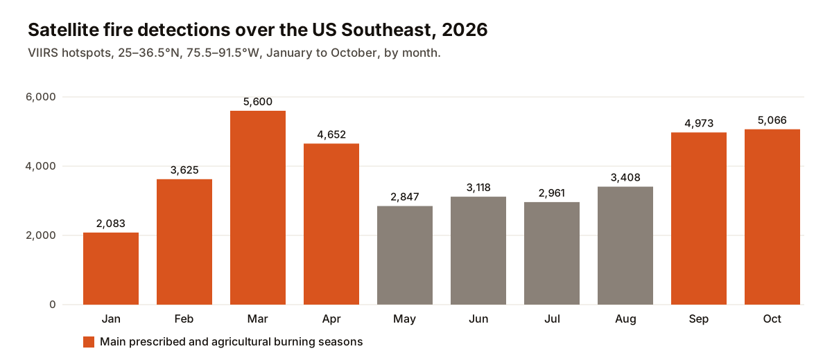
Detections climbed from about 2,100 in January to a peak of 5,600 in March, settled at around 3,000 a month through the summer, then rose again to nearly 5,000 in both September and October. Those two windows — January to April and September to October — accounted for 68% of all detections in the first ten months of the year. Late winter is the classic southeastern burning season, after leaf drop and before spring green-up. Autumn brings a second round of prescribed burns as summer humidity eases, along with harvest-season agricultural burning such as Florida's sugarcane fields.
The timing is also visible in when the fires were seen. In the busy burning months — February, March, September and October — about a third of detections came from the satellites' early-afternoon pass. In July, only about 7% did. Prescribed burns are lit by day and usually die down by evening, so they show up on afternoon passes; the summer detections are more often seen at night.
It isn't just the Southeast
- Agricultural burning: sugarcane fields in Florida and Louisiana, rice stubble in the lower Mississippi Valley and crop residue across the Plains all produce detections in their seasons.
- The Flint Hills: ranchers in Kansas and Oklahoma burn tallgrass prairie each spring, often enough to send smoke into cities hundreds of miles away.
- The West: forests in California, Oregon and the Rockies are increasingly burned in fall and spring, when conditions are safer than in summer.
- Australia: hazard-reduction burning is routine. In Queensland, 28% of the 8,559 fire incidents in FireRadar's feed between April and October 2026 were listed by the fire service as permitted burns. They peaked in August, then fell away as the fire danger climbed in September.
How to tell a planned burn from a wildfire
- Check the incident type. Many agencies label incidents as prescribed, planned or permitted burns. On FireRadar, tap the fire and look at its details.
- Look for a matching incident. A cluster of hotspots with no reported incident nearby, on a calm day in burning season, is more likely planned or agricultural. A hotspot near homes on a windy day with no explanation deserves attention.
- Check burn notices. State forestry agencies and many national forests and wildlife refuges post planned burns online or on social media the morning they light.
- Watch the pattern. Planned burns tend to appear in daylight, stay within a defined block and fade by night. Wildfires keep growing, often overnight too.
- Look at the weather. Burns are lit on days with moderate, steady wind. During a Red Flag Warning, prescribed burning is normally called off.
What about the smoke?
Prescribed burns are timed for weather that lifts and disperses smoke, but some still drifts into towns, especially overnight when smoke settles into low ground. If you're sensitive to smoke, check air quality on burn days and keep windows closed in the evening. Our smoke and AQI guide explains the levels.
On FireRadar's map, you can compare satellite hotspots with official incidents and turn on the air quality layer to see whether smoke is reaching you. Our guide to how satellites detect wildfires explains what each dot means.
Methodology: VIIRS 375 m detections in FireRadar's database from January 1 to October 31, 2026, inside a box from 25° to 36.5° N and 75.5° to 91.5° W, which covers Florida, Georgia, Alabama, South Carolina and parts of neighbouring states. Afternoon share uses the day/night flag on each detection. Queensland figures use the incident category reported by the state fire service.